Taken as a whole, Boroondara is one of the most socio-economically advantaged local government areas in Victoria. Nevertheless, not all members of the Boroondara community enjoy the same access to opportunities and resources. For some residents, Boroondara’s broader affluence may even serve to heighten disadvantage.
While the 2021 Census revealed that 41.9% of Boroondara households were in the top income quartile for Victoria, it is also true that:
- in March 2023, 3,550 Boroondara residents received Rent Assistance, 1,965 received a Disability Support Pension and 1,715 received JobSeeker (Department of Social Services benefit and payment recipient demographics quarterly data, 2023).
- At the 2021 Census, 980 Boroondara residents were living in social housing and more than 320 were homeless.
- In the December quarter of 2022, 1,977 Boroondara residents were unemployed (Informed Decisions Boroondara economic profile, 2023).
- At the 2021 Census, an estimated 1,507 Boroondara households (8.1% of mortgage holders) were in mortgage stress and an estimated 3,457 (19.2% of renting households) were in rental stress. These are households in the bottom 40% of income distribution which spend more than 30% of their income on mortgage repayments or rent (Public Health Information Development Unit 2023).
The Australian Bureau of Statistics SEIFA Indexes combine Census data such as income, education, employment, occupation, housing and family structure to summarise the socio-economic characteristics of an area. The SEIFA Index of Relative Socio-economic Disadvantage, or IRSD (shown in Map 1) contains only disadvantage indicators (for example, unemployment, low income or education levels, single-parent families, low-skill occupations, poor English proficiency). According to the IRSD, no Boroondara neighbourhoods are among the 20% most disadvantaged in Victoria, but some are among the 30% and 40% most disadvantaged in Victoria (Map 1).
Information about these and other Boroondara neighbourhoods is available from Informed Decisions Boroondara social atlas.
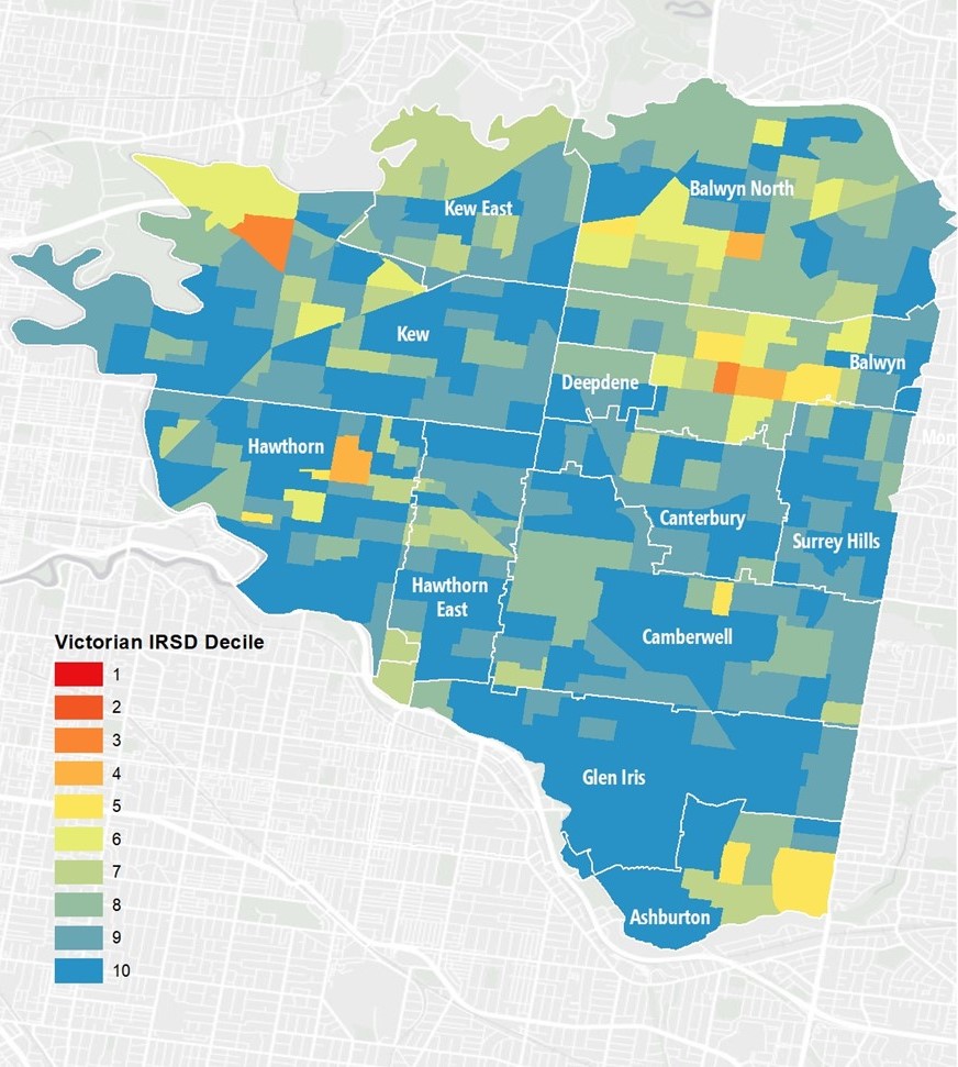
Map 1: Some Boroondara neighbourhoods (in orange on this map) are among the 40% most disadvantaged in Victoria based on the Australian Bureau of Statistics’ 2021 Index of Relative Socio-economic Disadvantage. Data source: ABS 2023 Socio-Economic Indexes for Areas (SEIFA), Australia